|
 When
it comes to collecting historical Americana, great
rarity is just one of the considerations for determining
a remarkable object. The historical significance
and context of an object, in terms of both the history
of its day and its significance for future generations
of Americans, is a great measure of the object's
"importance". This map is an excellent example of
a remarkably rare object that is also of great
importance. When
it comes to collecting historical Americana, great
rarity is just one of the considerations for determining
a remarkable object. The historical significance
and context of an object, in terms of both the history
of its day and its significance for future generations
of Americans, is a great measure of the object's
"importance". This map is an excellent example of
a remarkably rare object that is also of great
importance.
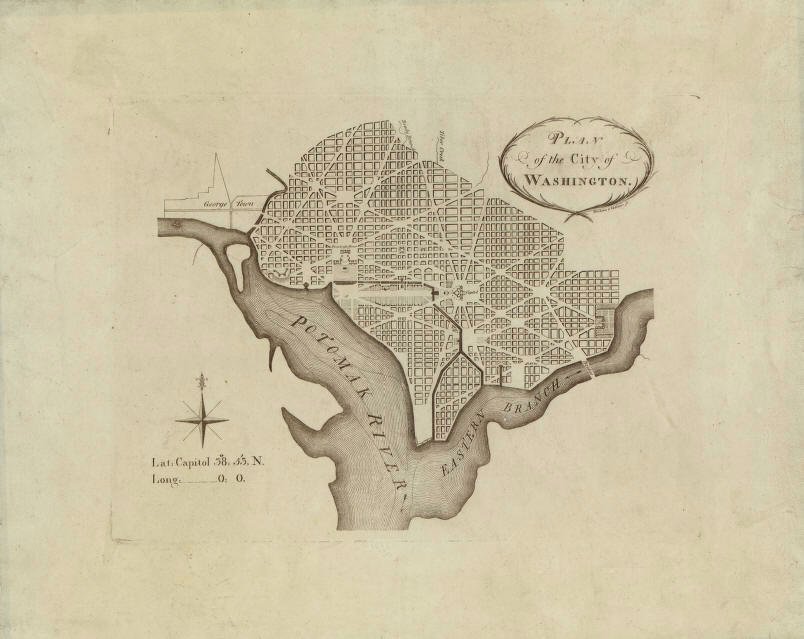
The map is the first
printed Plan of the City of Washington, D.C., printed by
Philadelphia engravers James Thackara and John Vallance
in early 1792. At the time, Philadelphia served as
the nation's capital. The July 16, 1790 Residence
Act passed by Congress authorized the new permanent
capital at an area to be selected by President
Washington. Washington announced the location of
the city on January 24, 1791, and Andrew Ellicott and
Benjamin Bannaker surveyed the area of approximately 100
square miles upriver from George Washington's Mount
Vernon estate at the point where the Potomac and Eastern
Branch Rivers meet. In March, 1791, Washington
designated Pierre L'Enfant to plan the city layout, and
Thomas Jefferson provided maps of European cities as a
reference for the design. By March, 1792, L'Enfant
was dismissed by Washington because of difficulties
working with other collaborators, including the city
commissioners responsible for the city's construction.
L'Enfant was replaced by his assistant and lead
surveyor, Andrew Ellilcott. By this time, much of
the plan was already complete, with Ellicott only making
minor modifications to L'Enfant's plan.
Philadelphia engravers
James Thackara and John Vallance, and Boston engraver
Samuel Hill, were commissioned to produce the first
official, large scale printed versions of Ellicot's
manuscript map of the city. Each was provided a
manuscript map to work from. Realizing that it
would take many months to engrave a highly detailed
large-scale official map, both Thackara and Vallance in
Philadelphia, and Hill in Boston, competing to be the
first to distribute printed maps to the public, produced
smaller, less detailed versions of the map to be printed
as inserts to periodical magazines of the day.
Thackara and Vallance's map was the first to appear in
March, 1792, in The Universal Asylum and Columbian
Magazine, followed by Hill's map in April, 1792, in
the Massachusetts Magazine. The official
large versions of the maps were not complete and printed
until the summer of 1792. Although the magazine
versions of these maps are remarkably scarce and sought
after today, they were mass produced and distributed in
the periodicals, and thus examples surface every few
years.1
There exists, however, a separately issued unfolded
version of the Thackara and Vallance map, printed from
the same plate but on higher quality paper with wide
borders and clear plate strike lines. These
separately issued versions are extraordinarily rare.
Two copies are held in the vaults of the Rare Maps
division of the Library of Congress; one with wide
borders and annotated in lead pencil "1st printed
edition of the L'Enfant plan", and one with trimmed
borders. I am aware of only two other copies held
in private hands, with this copy in the Rare Flags
collection being the fifth.
While there are surely
other maps that are as scarce or more so, in terms of
numbers of known copies, the map's extreme rarity
combined with its importance as the first printed map of
the capital of the United States, one of the great
capitals of the world and the seat of power for
generations of Americans, past, present and future,
elevates it as a national treasure.
1
Worldcat library search for the map shows four copies,
all of which are the Columbian Magazine edition: George
Washington University, Harvard University, Yale
University, University of Michigan. New York
Public Library search also shows a Columbian Magazine
version. Of the four other known copies of the
separately issued version that I am aware of, two copies
are in the Library of Congress, one copy is in the
possession of rare map dealer Barry Lawrence Ruderman,
and one copy was cited by Ruderman has having been sold
by the New York firm of Martayan Lan.
|